See site map for more information on the Hill of Tara
Read Tara Position Paper here
Download PDF version of this press release here.
Download 300 dpi print versions of these photos here:
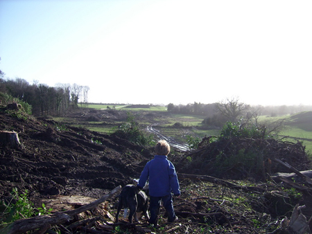
top photo - 'What hope for the future?' by Helen Rose
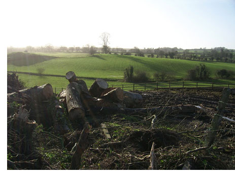
middle photo - 'Scar on landscape' by Helen Rose
See more of Helen's photos here.
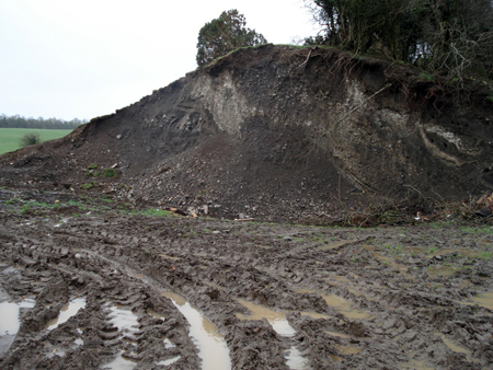
bottom photo - 'Rath Lugh' by Dr Muireann Ní Bhrolcháin
PRESS RELEASE
Update on Campaign to Save the Hill of Tara
MINISTER'S DIRECTIONS FLOUTED IN THE GABHRA VALLEY
When, on May 11, 2005, the Minister for the Environment, Dick Roche, gave directions on procedures for the development of the M3 freeway, he said that: "the removal of forestry and topsoil at Lismullin and Ardsallagh will be carried out under archaeological supervision; all construction topsoil stripping will be archaeologically monitored."
Tree felling and use of heavy digging machinery at Lismullin and at the base of Rath Lugh (one of Tara's outlying defensive fortifications) is not being carried out in accordance with the Minister's directions. It seems that standards of best archaeological practice are not being observed and that the directions are being openly flouted.
There is no archaeological supervision of forestry clearance at Lismullin. Neither is there any archaeological monitoring of large-scale earthmoving from the base of the Rath Lugh scarp. Such actions completely undermine Rath Lugh and the assurances given by the Minister in relation to this, one of our nation's most sensitive archaeological and historical landscapes. It must be assumed that the Minister and his senior archaeologist must know of this work that is in direct breach of the directives.
back to top
Rath Lugh is an important national monument in its own right but, as an integral part of Tara, its significance is even greater. It stands as a sentry over the Gabhra Valley guarding the northern and north-western approaches to the Hill and overlooks other nearby recorded archaeological monuments, namely a barrow and souterrain. It is extremely likely that other monuments that are not visible on the surface are also found within its immediate vicinity. Photographs show the destruction at the base of Rath Lugh – the stratified archaeological sediments can be seen in the right of photo below. If there were archaeological supervision such works would have been brought to a halt at the first sight of potential archaeological features. Heavy machinery, whether supervised or not, should not have been used or permitted in this area. Why is it necessary to commence such work under cover of darkness? This remains a mystery to all except, of course, those who sanctioned the work in the first instance. Health and Safety concerns aside, it is unlikely that someone will see freshly disturbed archaeological features in the dark – even if an archaeologist were present armed with miner's helmet and infra-red goggles. The Minister also said in a statement on May 11th 2005: "The directions which I have given represent a measured approach. They are both comprehensive and onerous. They protect heritage."
In fact, it appears that the Minister’s expressed wishes are being 'comprehensively' ignored.
Back to top
|